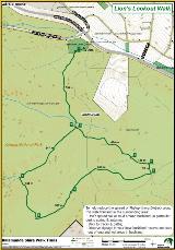
Lions Lookout Walk
May 1, 2019, 13:25 PM

This is a difficult walk in the Korung National Park, with some steep loose descents and taxing climbs. There are great views over Bickley Reservoir and the city with wildflowers in abundance in the spring time.
Map URL :
https://maps.kalamunda.wa.gov.au/intramaps22b/?project=Kalamunda&module=Recreation&startToken=97331b3d-37e0-42ad-8188-52102f7d7c4e
KML URL :
https://www.kalamunda.wa.gov.au/docs/default-source/trail-details/kml-walk-trails/lions_lookout.kml?Status=Master&sfvrsn=3e125c52_2&download=true
Distance :
4.0
km
|
Grade :
4
|
Time to Complete:
90
minutes
NOTE: All are approximate and will vary depending on individual fitness and ability levels
Suburb :
Lesmurdie
Location :
Lions Lookout off Welshpool Road, Lesmurdie, just east of Crystal Brook Road.
Description
The Lions Club of Lesmurdie generously provided a donation of infrastructure to the City, in order for the public to enjoy the spectacular views over the Bickley Reservoir. Lions Lookout puts on a colourful show of wildflowers from August to November each year.
Facilities available at this location include: BBQ, Car Park, Drink Fountain and Seating. Dogs on Lead at all times.
Find out more about Korung National Park via https://parks.dpaw.wa.gov.au/park/korung
Trail Description
The trail markers for this walk are pale blue
Trail Notes
Start point: The southern end of the car park.
1. Go through the white gate and walk in a southerly direction. The track skirts the brow of the hills with views over the Swan Coastal Plain, city and southern suburbs.
2. Take the left fork and walk uphill. The track climbs steeply to a small plateau with Wandoo trees and a view to the airport, city and coastal plain.
3. Arrive at a crossroad. Walk straight ahead, you will come across a marker in a tree immediately through the crossroad. The forest here consists of Jarrah, Casuarina and Banksia tree’s.
4. Turn right, walk towards a mesh fence bordering the Kanyana Wildlife Sanctuary.
5. Before reaching the fence, turn right as indicated by the markers and head in a westerly direction. Ignore a well made track to the left, continue in a westerly direction. The coastal plain can be seen through the trees.
6. After a steep decent out of the Jarrah Forest, the track is more open country with views on the left of the Bickley reservoir and the Bickley Valley.
7. Most Southerly part of the walk.
8. Take the right fork at the T-Junction at a watercourse. Walk uphill.
9. Turn left at this junction and return to the car park.
To help reduce the spread of Phytophthora Dieback:
- Don’t spread soil or mud around bushland, in particular during spring & autumn;
- Stick to tracks & paths;
- Observe signage in your local bushland reserve and stay out of quarantined areas in bushland.